- Distance – 11 Km
- Ascent – 960 m
- Height – 989 m
- My Time – 6.5 hours
- Season completed – Winter
- Difficulty – 6 / 10
- Weather – Freezing temperatures, cloud was low, but lifting. Wind was moderate.
- Just want to see the photos to get a feel for the hike – click here
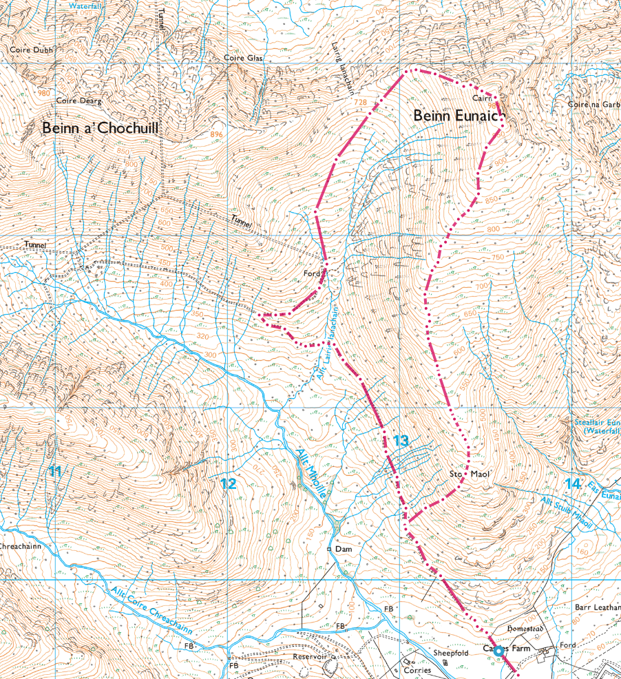
- Route Map

Starting Off
This starting point isn’t a hard one to get right, space for maybe 3 cars without blocking access. I think if its full then you can go on a little bit further over the bridge for some more space, but I wasn’t paying particular attention to that as there was zero cars when I turned up (or left). The actual spot is located at OS grid ref NN 13557 28769.
You’ll be driving along the A85, and shortly after passing the junction for the A819 you’ll need to indicate off to the right to join the B8077. Drive for a few hundred meters and right before you cross a rather small bridge you’ll see a gate with some space on your right hand side. Park there, obviously making sure not to block the gate.
Change of Plans
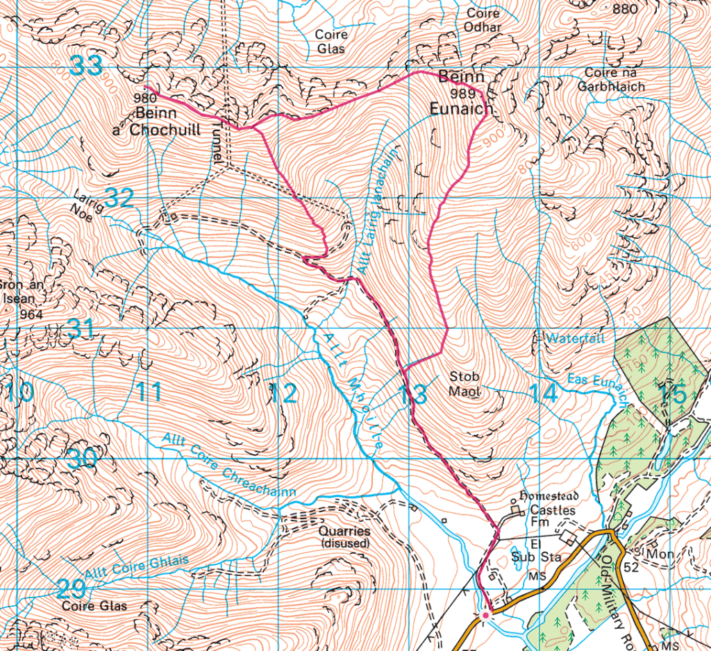
So I’ll get straight to the point here. Two images, one is off my planned route, the second is from my actual route. Couple of things to notice, one I didn’t do two munro’s. I missed out Beinn a’ Chochuill and perhaps much less apparent unless you look carefully at the map is the route up Beinn Eunaich.
Beinn Eunaich is a steep hill, not quite a scramble, but really not far off it. Reading route guides elsewhere had you doing Beinn a’ Chochuill first then Beinn Eunaich and coming down that really steep section. Not something I’d pick for a route down if I could avoid it – which you can.
Recommendation
When planning a route, don’t just take some other sites (or even this) route and use that without inspecting it to see if it works for you. I dislike coming down steep slopes, but I really don’t mind going up them. Personally I find it easier and more enjoyable to climb a steeper slope and pick a more gradual decline. So for this I decided to do the route in the reverse order from what I read elsewhere.
Read the Map

This was my route, but if I was to take the original route I’d have walked up (actually come down) close to where the ’13’ is on the map. Clearly this is steeper due to the contours being much closer together.
I’d really not recommend coming down that part as if you head up/down where I went or even a little bit further south it will reduce the strain quite a bit. And it was steep enough!
What about the walk??
So what about the actual walk, well doing just the one does make it short – but this is a winter walk and as such daylight hours are short, so if you want to take your time and enjoy whats around then settling for just the one will be great. If it’s winter and the weather is playing ball then you could certainly do both.
Once you leave your car you head across the bridge and of to your left and follow the farm track. You’ve got to go through a couple of gates and I had the pleasure of walking through around a dozen or more highland cows. They all seemed friendly enough, must be used to walkers.

Once heading up the track, I’d actually recommend when you hit the 150 m in altitude that you then use that as a marker for heading up and off the path. I waited till I was a bit further on, which actually made it a tad harder. Doesn’t matter too much, but if I was to do it again, I’d leave the path at that 150 m mark.
From then on it’s a case of just keep on going up and up. It levels off a bit at around 450 m, then it’s a nice gentle incline until you reach the summit at 989 m. So certainly nothing to worry about, but there isn’t any rest till you do get to the top. Think I noticed one false summit, but that could have been due to the clouds as I couldn’t see that far ahead at the time. Thought I’d reached the top, but nope I was only at around 940 m. So pretty close, but note quite there.

When the clouds did lift a little the views were amazing. The above was taken while on the long saddle of Beinn Eunaich looking at the slope of Beinn a’ Chochuill. If you where to climb that, then the route up would be the small ridge seen in the middle of the photo.
Weather
All weather reports put the weather as ok in the morning, with a gap of clear skies and by late afternoon it was to take a turn for the worse. In the end I think the weather got it mainly right, but the morning had a lot more cloud than was forecast. So felt like I was being much more cautions with my plan in my head than I would have been if it was clear skies as I expected first thing.

The cloud was coming and going a bit by the time I was close to the summit. Nothing on the route up will cause issues, the most difficult part was the steep section on the way up and I could see that putting some people of this for a casual day out. As I approached the top visibility wasn’t great and the snow as it does make it harder to tell what is what. The summit has a cairn/small shelter, but it was snow covered. So of no real use if you wished or needed to get out of the wind for a bit.

Couldn’t make out how close to the edge the shelter was. The map shows a very steep/sheer drop off on the east side, but with the snow and cloud cover I wasn’t for venturing beyond the immediate proximity of the cairn.

Caution – the cairn looks very close to the edge on the map. The wind was west to east, so cornicing could be a real issue in winter here.
Break in the clouds
Finally I got a break in the clouds a few minutes after leaving the summit and the views where spectacular. Below is Beinn a’Chochuill. If I had carried on I’d have gone along the ridge on the middle right and then down the one on the left. The hills in the background are the ones that surround the Cruachan reservior. Now that’s a great walk for the summer.

With the clouds all but gone, you could see for miles once more. Below is the route I descended by and below that is the view if I was to turn 180°. You can clearly see the route to go up to reach Beinn a’ Chochuill.


Decision Time
It had just gone past midday, so I had around 3-4 hours of light left. The clouds looked like they were disappearing – I could clearly see the route to take. What to do? I was very very tempted to keep going, but in the end I knew that the weather said a weather front was coming in and it was going to get very cloudy when that happened.
So as I reached the low point between Beinn Eunaich and Beinn a’ Chochuill I carried on down the slope rather than going back up.

The right choice
As I started coming down the clouds came back as quick as they had left. I had a clear route down, the snow only came down as far as 400 m. I’d had a good hike so far, and now I was essentially on the safe route home. Barring putting my foot into a hole and breaking it something like that I was safe. So I was happy and I’ll be back for Beinn a’ Chochuill another day. From that point on, I don’t think I seen the summit again due to clouds. So that always helps reassure you that it was the right call.

Should you choose the same route then at roughly 450 m you can join the well formed track to take you back. There are tunnel entrances for water and the tracks are obviously still used to maintain them.


Route Map